Digital Maps Available
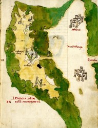
Euboia from Cristoforo Buondelmonti’s manuscript Liber Insularum Archipelagi (15th century)
Several of the rarest maps from the Gennadius collections were photographed digitally this summer by archaeological photographers Jennifer and Arthur Stephens with the help of historian Alexis Malliaris. The maps photographed (900 digital images in total) include Buondelmonti’s isolario, Basilicata’s maps of Crete, maps by cosmographer André Thevet and many more.
The maps will be available online when all maps have been photographed digitally. In the interim, those interested in using a map from these collections can contact
Katerina Papatheophani of the Photographic Archives.